Birmingham City Council
Tree preservation zone
There is a problem
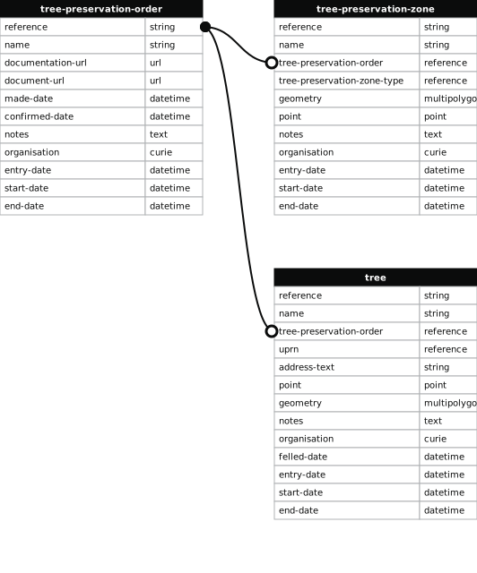
- 1000 entries with tree-preservation-order field must match the reference field in the tree preservation order dataset
THE BIRMINGHAM (LAND AT 27 - 35 HAMSTEAD HILL, HANDSWORTH WOOD) TPO 1999
- reference
- 808
- name
- THE BIRMINGHAM (LAND AT 27 - 35 HAMSTEAD HILL, HANDSWORTH WOOD) TPO 1999
- tree-preservation-order
- TPO 808
- tree-preservation-zone-type
- area
- geometry
- MULTIPOLYGON (((-1.930815 52.522927,-1.930839 52.522881,-1.930838 52.522874,-1.930822 52.522867,-1.930832 52.522848,-1.930851 52.522844,-1.930856 52.522840,-1.930894 52.522769,-1.930977 52.522606,-1.930959 52.522594,-1.930968 52.522575,-1.930984 52.522575,-1.930992 52.522572,-1.931033 52.522490,-1.931021 52.522484,-1.931031 52.522461,-1.931045 52.522459,-1.931107 52.522322,-1.931110 52.522313,-1.931104 52.522308,-1.931088 52.522301,-1.931097 52.522278,-1.931121 52.522280,-1.931125 52.522279,-1.931129 52.522275,-1.931169 52.522179,-1.931167 52.522175,-1.931150 52.522171,-1.931165 52.522141,-1.931175 52.522143,-1.931181 52.522141,-1.931189 52.522134,-1.931207 52.522093,-1.931211 52.522080,-1.931218 52.522066,-1.931219 52.522047,-1.931214 52.522036,-1.931203 52.522033,-1.931212 52.522013,-1.931225 52.522013,-1.931243 52.521999,-1.931322 52.521778,-1.931322 52.521773,-1.931319 52.521765,-1.931308 52.521758,-1.931315 52.521735,-1.931334 52.521730,-1.931343 52.521723,-1.931358 52.521674,-1.931351 52.521668,-1.931343 52.521666,-1.931354 52.521643,-1.931368 52.521640,-1.931371 52.521637,-1.931385 52.521594,-1.931372 52.521586,-1.931376 52.521576,-1.931391 52.521571,-1.931418 52.521495,-1.931249 52.521476,-1.930782 52.521419,-1.930298 52.521364,-1.930144 52.521349,-1.929728 52.521302,-1.929465 52.521269,-1.929286 52.521348,-1.929060 52.521440,-1.929004 52.521477,-1.928890 52.521524,-1.928681 52.521602,-1.928820 52.521751,-1.928933 52.521858,-1.929120 52.522010,-1.929261 52.522111,-1.929347 52.522164,-1.929635 52.522328,-1.929678 52.522355,-1.929818 52.522436,-1.929850 52.522453,-1.929877 52.522470,-1.929925 52.522492,-1.930005 52.522536,-1.930057 52.522562,-1.930094 52.522577,-1.930282 52.522671,-1.930342 52.522698,-1.930395 52.522726,-1.930815 52.522927)))
- point
- POINT (-1.93019 52.52194)
- notes
- The shaded area represents those properties which fall within the outline of a Tree Preservation Order. To precisely identify trees protected by the Order, you can request a copy of the tree preservation order at the following link.
- entry-date
- 2026-10-16
- start-date
- end-date
How to fix this issue
Your data is missing a tree-preservation-order.
The tree preservation zone guidance explains how to fix the issue:
tree-preservation-order
The reference for the tree preservation order that covers this zone.
How to improve Birmingham City Council’s data
- Fix the errors indicated
- Use the check service to make sure the data meets the standard
- Publish the updated data on the endpoint URL