Birmingham City Council
Tree preservation zone
There is a problem
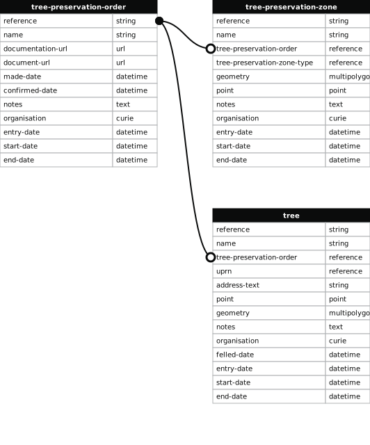
- 1000 entries with tree-preservation-order field must match the reference field in the tree preservation order dataset
THE BIRMINGHAM (LAND ADJOINING OSCOTT COLLEGE, OFF COLLEGE ROAD, PERRY COMMON) TPO 1987
- reference
- 320
- name
- THE BIRMINGHAM (LAND ADJOINING OSCOTT COLLEGE, OFF COLLEGE ROAD, PERRY COMMON) TPO 1987
- tree-preservation-order
- TPO 320
- tree-preservation-zone-type
- area
- geometry
- MULTIPOLYGON (((-1.858285 52.538523,-1.858038 52.538528,-1.857635 52.538533,-1.857068 52.538537,-1.856554 52.538532,-1.856445 52.538533,-1.856216 52.538532,-1.855615 52.538523,-1.855369 52.538516,-1.855321 52.538916,-1.855303 52.539105,-1.855249 52.539566,-1.855208 52.539951,-1.854984 52.539950,-1.854779 52.539946,-1.854643 52.539946,-1.854072 52.539940,-1.853954 52.539936,-1.853684 52.539932,-1.852699 52.539920,-1.852465 52.539914,-1.850703 52.539891,-1.850683 52.540161,-1.850667 52.540436,-1.850643 52.540801,-1.850641 52.540869,-1.850642 52.540937,-1.850645 52.540972,-1.850674 52.541108,-1.850691 52.541160,-1.850741 52.541260,-1.850766 52.541302,-1.850832 52.541400,-1.850904 52.541491,-1.851091 52.541708,-1.851166 52.541791,-1.850613 52.542016,-1.850713 52.542168,-1.851892 52.541711,-1.851820 52.541548,-1.851830 52.541504,-1.851842 52.541462,-1.851823 52.541441,-1.851754 52.541340,-1.851623 52.541131,-1.851595 52.541081,-1.851566 52.541021,-1.851541 52.540950,-1.851524 52.540808,-1.851509 52.540639,-1.853974 52.540670,-1.854717 52.540675,-1.855505 52.542145,-1.855029 52.542291,-1.855719 52.542903,-1.856372 52.543012,-1.857735 52.543992,-1.857407 52.544208,-1.857466 52.544571,-1.857665 52.544674,-1.857878 52.544869,-1.858235 52.545100,-1.858827 52.544788,-1.858856 52.544817,-1.859057 52.544776,-1.858708 52.544417,-1.858681 52.544363,-1.858980 52.544347,-1.859373 52.544292,-1.859499 52.544257,-1.859474 52.544214,-1.859928 52.544116,-1.860524 52.543991,-1.861392 52.543813,-1.861376 52.543788,-1.861369 52.543769,-1.861180 52.543449,-1.860830 52.542866,-1.860720 52.542679,-1.860681 52.542617,-1.860563 52.542415,-1.860508 52.542312,-1.860280 52.541929,-1.860228 52.541847,-1.860135 52.541686,-1.860055 52.541552,-1.859584 52.540748,-1.859515 52.540640,-1.859477 52.540573,-1.859470 52.540554,-1.859426 52.540474,-1.859414 52.540456,-1.859253 52.540179,-1.858818 52.539442,-1.858699 52.539235,-1.858410 52.538743,-1.858285 52.538523)))
- point
- POINT (-1.856986 52.541432)
- notes
- The shaded area represents those properties which fall within the outline of a Tree Preservation Order. To precisely identify trees protected by the Order, you can request a copy of the tree preservation order at the following link.
- entry-date
- 2026-10-15
- start-date
- end-date
How to fix this issue
Your data is missing a tree-preservation-order.
The tree preservation zone guidance explains how to fix the issue:
tree-preservation-order
The reference for the tree preservation order that covers this zone.
How to improve Birmingham City Council’s data
- Fix the errors indicated
- Use the check service to make sure the data meets the standard
- Publish the updated data on the endpoint URL