Birmingham City Council
Tree preservation zone
There is a problem
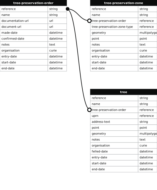
- 1000 entries with tree-preservation-order field must match the reference field in the tree preservation order dataset
THE BIRMINGHAM (THE PRIORY, BRISTOL ROAD SOUTH, NORTHFIELD) TPO 1975
- reference
- 260
- name
- THE BIRMINGHAM (THE PRIORY, BRISTOL ROAD SOUTH, NORTHFIELD) TPO 1975
- tree-preservation-order
- TPO 260
- tree-preservation-zone-type
- area
- geometry
- MULTIPOLYGON (((-1.964353 52.419302,-1.964128 52.419192,-1.963850 52.419059,-1.963644 52.418956,-1.963531 52.418917,-1.963169 52.418776,-1.962796 52.418628,-1.962515 52.418512,-1.961967 52.418295,-1.961718 52.418194,-1.961481 52.418102,-1.961293 52.418026,-1.961040 52.417929,-1.960966 52.417898,-1.960914 52.417871,-1.960885 52.417866,-1.960861 52.417859,-1.960245 52.417604,-1.960231 52.417596,-1.960207 52.417575,-1.960167 52.417526,-1.960061 52.417418,-1.960038 52.417386,-1.959536 52.417414,-1.959435 52.417416,-1.959391 52.417415,-1.959317 52.417422,-1.959271 52.417428,-1.959202 52.417445,-1.959140 52.417468,-1.959024 52.417522,-1.959138 52.417673,-1.959188 52.417747,-1.959253 52.417853,-1.959315 52.417964,-1.959356 52.418022,-1.959434 52.418065,-1.959487 52.418107,-1.959554 52.418171,-1.959620 52.418253,-1.959674 52.418328,-1.959754 52.418432,-1.959833 52.418522,-1.959865 52.418568,-1.959892 52.418611,-1.959878 52.418616,-1.959903 52.418650,-1.959994 52.418746,-1.960092 52.418815,-1.960100 52.418818,-1.960162 52.418871,-1.960188 52.418891,-1.960216 52.418909,-1.960240 52.418921,-1.960306 52.418977,-1.960522 52.419114,-1.960707 52.419252,-1.961213 52.419426,-1.961651 52.419573,-1.961783 52.419619,-1.961915 52.419659,-1.962158 52.419737,-1.962242 52.419766,-1.962284 52.419778,-1.962392 52.419820,-1.962475 52.419857,-1.962657 52.419934,-1.963162 52.420135,-1.964051 52.419604,-1.964092 52.419578,-1.964464 52.419357,-1.964409 52.419322,-1.964353 52.419302)))
- point
- POINT (-1.961653 52.418803)
- notes
- The shaded area represents those properties which fall within the outline of a Tree Preservation Order. To precisely identify trees protected by the Order, you can request a copy of the tree preservation order at the following link.
- entry-date
- 2026-10-14
- start-date
- end-date
How to fix this issue
Your data is missing a tree-preservation-order.
The tree preservation zone guidance explains how to fix the issue:
tree-preservation-order
The reference for the tree preservation order that covers this zone.
How to improve Birmingham City Council’s data
- Fix the errors indicated
- Use the check service to make sure the data meets the standard
- Publish the updated data on the endpoint URL